Environment Government Police & Fire
As wildfire season flares up, here’s how to evaluate your home’s risk
Our wet spring brought a welcome reprieve from wildfires and smoke that have plagued Western Washington in recent years. But summer isn’t over by a long shot, and wildfire season is just getting started.
Several fires that started last week in Eastern Washington — one a brush fire that led to the evacuation of a small town southeast of Spokane — are a reminder of the danger and disruption caused by wildfires. Even closer, a brush fire threatened two homes in nearby Lakewood last weekend.
Wildfire risk in our region
It’s not just Eastern Washington that’s at risk.
The weather on the west side of the mountains is growing hotter and drier due to climate change. That increases the likelihood and intensity of wildland fires in Western Washington, said Assistant Fire Chief Todd Meyer of Gig Harbor Fire & Medic One.
While this year’s wet spring lowers the risk initially, it also contributes to vegetation growth. That adds fuel to forests and grasslands in the dry season, meaning fires burn hotter and move more quickly. “It’s kind of a Catch-22,” Meyer said.

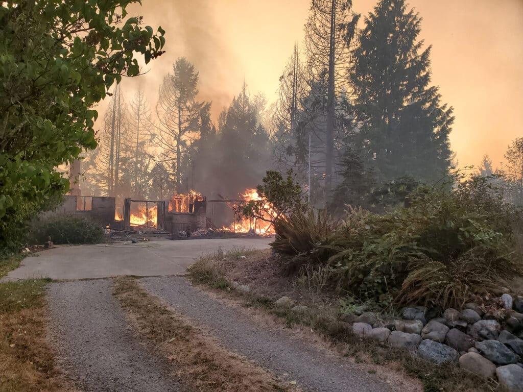
The 2020 Sumner Grade Fire near Bonney Lake was a wildland fire in Eastern Pierce County that caused the evacuation of thousands and destroyed a number of structures including homes.
The 2020 Sumner Grade Fire near Bonney Lake in Eastern Pierce County forced thousands to evacuate and destroyed homes and other structures. Another intense wildfire in Graham erupted in the same early September time frame. Both were caused by downed power lines igniting dry vegetation.
Read our story, then review the five action areas below with steps to mitigate your property’s wildfire risk. Many of the steps cost little, some cost only sweat and time.
Wildfire season ramping up
State Commissioner of Public Lands Hilary Franz hammered home the risk at a press briefing Friday on the fires in Eastern Washington.
“We’ve been blessed to have a light fire season, but we need to be very aware that our fire season is now upon us, Franz said. “And with the hotter, drier conditions and windy conditions, fires can erupt very quickly. This is a prime part of the season for severe fire potential. As we’ve seen just in the past few days, it is going to likely get worse before it gets better.”
Franz urged people to “follow best practices” when outdoors and taking part in recreational activities. “Don’t be the spark,” she said. “In conditions like these, one might be all it takes.”
Gig Harbor, Key Peninsula at risk
A 2020 brush fire in Gig Harbor — likely caused by sparks from a vehicle or a cigarette tossed from a window of a car on Highway 16 — spread to an acre along Cushman Trail. It threatened nearby commercial buildings, Meyer recalled.
“We were just on the cusp of evacuating places if the fire had gotten any bigger or was threatening more people,” Meyer said, in a video produced by his department that year to educate people about protecting their property and family from wildfire.
“It can happen even here in Gig Harbor,” Meyer said in a companion video.
“It’s all about reducing the risk,” he said. “We’re not going to eliminate it, but how do we reduce the risk?”

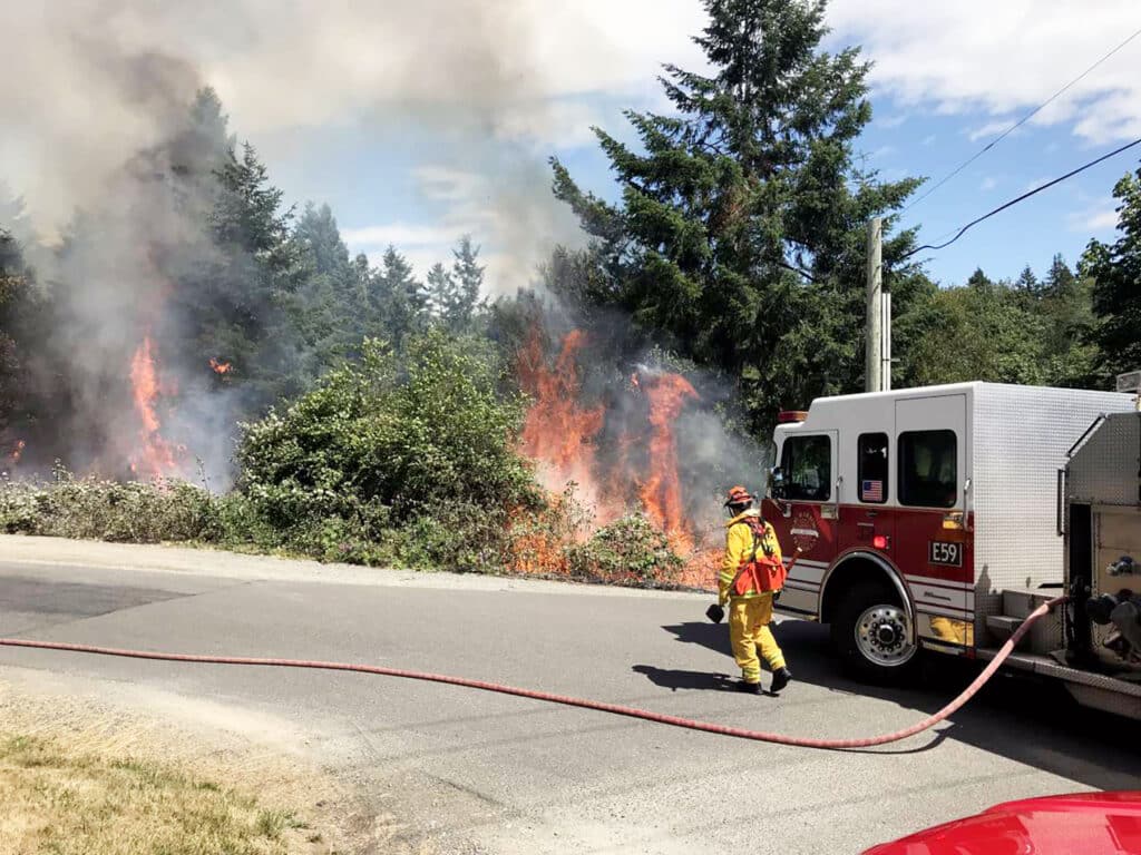
A fire crew from Gig Harbor Fire & Medic One fights a brush fire in 2019 at Murphy Drive and East Bay Drive.
Make a plan
The Firewise USA program of the National Fire Protection Association describes how communities and local governments can work together to create resilience to wildfire in their areas.
“Even if it’s a down year, this is the time to think about, hey, what can we do to prepare,” Meyer said. “For me, it’s these communities beforehand having it done before the fire hits, for lack of better words. Doing the work before there’s smoke in the air.”
But Meyer said individuals needn’t wait for larger efforts to get underway to start picking off tasks that will protect their homes. The NFPA offers guidance for homeowners.
Even if you can’t do it all this year, something is better than nothing, Meyer said, quoting the trite but true adage: “How do you eat an elephant? One bite at a time.”
Preparing your property and making an evacuation plan will help your family in the event of a wildfire or other natural disaster. It will also aid emergency responders by reducing the load on their resources.
Where you live matters
You may have heard of the Wildland Urban Interface or WUI, defined by the Washington Department of Natural Resources as “those areas where human development meets areas that are covered in more than 50% wildlands (forests, sagebrush-steppe or grasslands). There’s also the “Wildland Urban Intermix” where structures intermingle with wildlands.
Living in the WUI or intermix areas does not automatically equate to high fire risk, according to the DNR. More important, says Meyer, is to assess the combination of risk factors specific to your property.
Alas, those features Gig Harbor and Key Peninsula residents find most endearing — stunning hillside views and waterfront properties — do add to the risk.

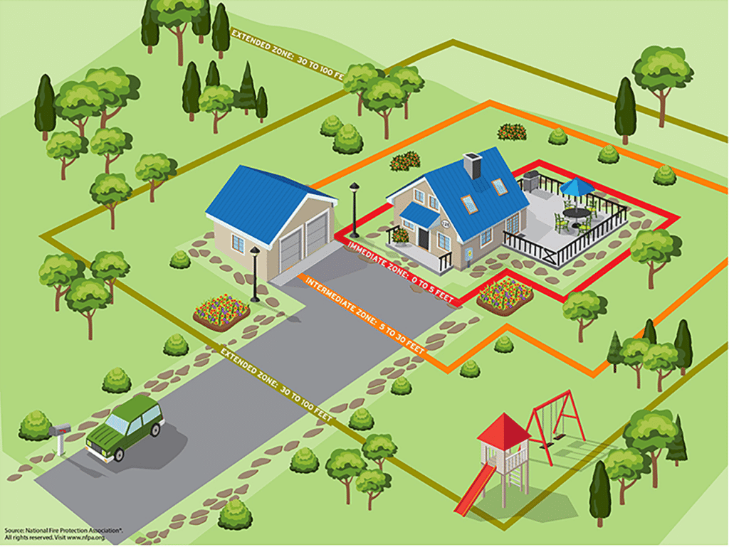
This graphic from the National Fire Protection Association illustrates the Home Ignition Zone concept, three designated areas within which getting rid of combustible materials is recommended to reduce wildfire risk. The theory is that reducing burnable materials in each of these zones will lead to layers of defense, as the fire passes quickly through without gaining a foothold.
Understanding the ‘Home Ignition Zone’
The “Home Ignition Zone” concept was developed in the 1990s by retired USDA Forest Service fire scientist Jack Cohen. It is based on experimental research into how homes ignite due to the effects of radiant heat.
The HIZ has three sub-zones: immediate (zero to five feet); intermediate (five to 30 feet) and extended (30 to 100 feet, and up to 200 feet). The theory is that reducing burnable materials in each of these zones will lead to layers of defense against a wildfire, as the fire passes quickly through without gaining a foothold.
More important than getting hung up on precisely measured zones, said Meyer, is to assess what you can do: in the immediate perimeter of your home, in your landscaped yard, and in surrounding woodland, shrubby or grassy areas.
Each home is different. So, too, are each homeowner’s resources and capability.
The National Fire Protection Association identifies the immediate home area as the highest priority. But Meyer says people shouldn’t get hung up on a linear approach.
He suggests using the Home Ignition Zone as a guideline as you tailor-make make your wildfire mitigation plan. Start small on the low-hanging fruit (regardless of zone) while keeping sight of long-term goals.
Assess your property’s risk
Evaluate the following as they pertain to your property:
- Location: Homes close to wooded areas, brush or grassland are at increased risk.
- Topography: Fire tends to burn uphill (although there are exceptions).
- South-facing aspect: Southern slopes get more sun and tend to dry out faster than north-facing slopes.
- Winds: Waterfront areas are subject to winds off the sound that can affect the behavior of a wildfire.
- Single access: Many waterfront properties (or other rural, isolated sites) have just one way in, one way out.
- Resources: The Pierce Conservation District has foresters who can provide assistance to small forest landowners interested in improving forest health and managing for a variety of needs including wildlife habitat, wildfire prevention and water quality.
Reduce natural fuels
- Remove dead leaves, pine needles and other debris from the ground around buildings, roofs and gutters.
- Move wood piles away from building foundations.
- Water grass or keep it short.
- Remove ornamental plants and bushes from up against the house.
- Landscape with fire resistant plants, following tips from the Washington Department of Natural Resources in partnership with other agencies.
- Clear debris from “void spaces” under decks or in vents, for example. Install screens to block embers.
- Rake beauty bark away from your foundation so there’s at least six to eight inches of space between the bark and your bottom board of siding. Better yet, get rid of the beauty bark and use pea gravel for a ground cover.
- Clear brush, like that overgrown pile of blackberries out back. Some people have found success renting goats to clear the land.
- Thin wooded areas and get rid of lower limbs on remaining trees, which can act as “ladder fuel” to ignite the crown of a tree and cause the fire to spread faster. Prune trees up to six to 10 feet from the ground. For shorter trees, do not exceed more than one-third of the overall tree height.
Better home fire protection
- Remove patio furniture from decks and store when not in use. Embers can ignite cushions and decorative items.
- Remove anything stored under decks.
- Secure your propane tanks. For large tanks, remove dead grass, debris and anything flammable from under and around the tank. Keep trees and shrubs trimmed back from the sides and above tank.
- Turn off and disconnect small, portable propane tanks. Place the tank away from the home where it can be easily seen.
- Store gasoline and chemicals in a shed away from your home, not the garage or adjacent workshop.
- Remodeling or building new? For siding, use fire resistant materials like fiber cement siding, stucco, brick, stone, and aluminum or steel siding. Don’t forget soffits and overhangs.
- For new or replacement roofing materials, select metal or tile.
- For existing roofs, replace or repair missing shingles or roof tiles to prevent ember penetration.
Ensure Emergency Vehicle Access
- Make sure the entrance to your home, whether driveway or community access road, is well marked with your house address clearly visible. This aids not only fire personnel but other emergency responders in getting to you quickly.
- Keep your driveway well maintained and trimmed back of excess vegetation. This not only helps emergency personnel find your home, but allows for easier emergency vehicle access.
- If your property has just one way in, one way out, consider leaving sooner in the event of a fire or other natural disaster. (See evacuation plan below).
- Consider installing a fire hydrant. Explore cost-sharing with neighbors. Consult with your local water purveyor to assess feasibility and cost.
Make an Evacuation Plan
The Ready, Set, Go! Program, managed by the International Association of Fire Chiefs, educates individuals on how to prepare for evacuation in the event of a wildfire or other natural disasters like floods, earthquakes, volcanic eruptions and storms. There are three levels.
Be Alert: Level 1
- Check local news.
- Tell neighbors.
- Help others.
Be Ready: Level 2
- Make an emergency plan. Write it down, and involve all family members.
- Set a meeting place.
- Make a plan for pets and livestock.
- Share the evacuation plan with someone outside your area.
- Prepare your emergency evacuation kit (ideally before disaster looms) including: Personal documents, phone and chargers, weather radio, flashlights, food and water, medications and first aid kit, toiletries and dry clothing, toilet paper, tool kit (From Pierce County Department of Emergency Management).
Leave Now: Level 3
- Evacuate the area.
- Check media for more information.

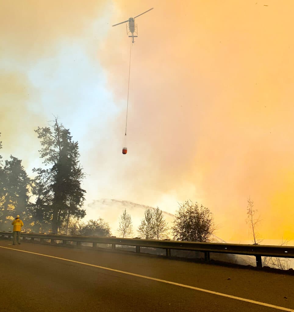
A fire crew in 2020 fights the Sumner Grade Fire near Bonney Lake, a wildland fire that caused the evacuation of thousands of East Pierce County residents and destroyed a number of structures including homes.
